Tag Archives: NASA

NASA’s Global Freshwater ‘Selfie’ Catches Us in the Act of Over-Depletion

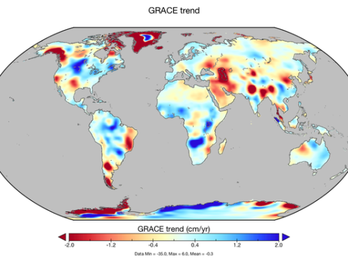
NASA GRACE image

Image: NASA, based on study by Matthew Rodell, et al, 2018

U.S. space agency NASA’s new analysis of 14 years of satellite data shows rapid change in the world’s freshwater supply in startling detail never captured before. The 34 “trends” in the data picture not only the effects of climate change, like worsening droughts, but of human over-use, such as pumping out underground aquifers to irrigate crops. To a lesser extent, they show natural change over time. They also  indicate where water scarcity is most likely to reach crisis mode and lead to armed conflict over resources and/or forced human migration.

“There are implications in that map for food security, for water security and for human security in terms of things like conflict and climate refugees,” said Dr. Jay Famiglietti, a water-resources expert affiliated with NASA’s Jet Propulsion Laboratory and co-author of a paper on the findings in the journal Nature. He and other experts said the mapping should serve as a wake-up call for policymakers.

Read more:

NASA Satellites Reveal Major Shifts in Global Freshwater — NASA

Emerging Trends in Global Freshwater Availability — Nature

This Is an Eye-Opener’: Changes in Global Water Supply Hint at Future Conflicts and Crises — The Globe and Mail

Water Shortages to Be Key Environmental Challenge of the Century, NASA Warns — The Guardian

NASA Finds ‘Human Fingerprint’ in Many Areas of Water-Supply Change Worldwide — USA Today

First Map of Global Freshwater Trends Show Human Fingerprint — Axios

Related posts:

California Drought: Overcoming History to Reduce SoCal Water Waste

Study Finds We Vastly Underestimate Water Management’ s Depletion of Groundwater

It’s Long Past Time to Police Big Agriculture’s Water Waste

World Water Day: UN World Water Development Report Warns of Global Crisis by 2030

At the Point of ‘Peak Water,’ Our Foreseeable Future Grows Shorter

Mapping the World’s Most Water-Stressed Countries

Serious Water Conservation Demands Layered Approach and Emotional Commitment

Study: Freshwater Shortage Will Double Climate Change’s Impact on Agriculture

Unchecked Emissions Will Drain Water Resources, Warns Leaked U.N. Report

Leave a comment

Filed under Climate Change, Conflicts, Drought, Environment, Global, Groundwater, Rivers and Watersheds, Science, Sustainability, Water Resources, Water Shortage

Top 5 Non-Lethal Uses for Drones

Image: Flying Eye

Image: Flying Eye

Happiness is not a police state, and unmanned aerial vehicles aren’t just for the war machine anymore. Though many of us associate drones with bomb strikes and government surveillance, their civilian use is growing more widespread and attracting massive investment. It’s going to go far beyond recent headline grabbers (e.g., Domino’s pizza-delivery tests and Amazon.com CEO Jeff Bezos saying on “60 Minutes” that deliveries by drone will be off the ground in 2015, depending on FAA approval). Essentially, anything that calls for a bird’s-eye view, aerial photgraphy, or lightweight deliveries can benefit from drone service. In no particular order, here are five favorites, already underway:

Monitoring and protecting wildlife.  Some early indicators suggest drones are better at spotting wildlife than people in planes and helicopters are, while also reducing costs and risks to human life. Researchers have found success deploying drones to survey dugongs, a vegetarian marine mammal related to the manatee, in Shark Bay, on the western Australia coast. The U.S. Geological Survey uses drones to count sandhill crane populations. The devices are also used to track endangered Sumatran orangutans.

Delivering medicine. The Bill and Melinda Gates Foundation has awarded a $100,000 grant to George Barbastathis and collaborators at the Harvard-MIT Division of Health Sciences and Technology in the U.S. They’re working on unmanned aerial vehicles that health care workers can deploy via cell phones to swiftly deliver vaccines and the like.

3-D mapping for everyone. Using a lightweight drone and powerful new software, almost anyone will soon be able to create precise 3-D maps for any number of uses, such as crop management, facilities monitoring and disaster relief operations.  Watch Pix4D co-founder Olivier Kung’s TEDx talk on the subject.

Search-and-rescue. The Royal Canadian Mounted Police reported what they believed to be the first use of a drone to rescue an accident victim. After a late-night car accident in remote Saskatchewan in May 2013, an injured and disoriented man called police but couldn’t report his location. Worse, he wandered far from the crash site.  A helicopter search failed to find the man, even with night-vision gear, but an unmanned drone with an infrared camera did the job. Without it, he would not have survived the night.

Hurricane tracking. Improvements in drone technology have increased the aircraft’s range and flying time, making them invaluable for gathering weather data. An airplane can’t safely stay inside a hurricane for 30 hours, as some drones can.  NASA and Northrop Grumman have teamed up on a $30 million project to monitor storms as they evolve. A University of Florida project is looking at doing similar work with swarms of tiny drones.

Leave a comment

Filed under Agriculture, Conservation, Environment, Industry, Natural Disasters, North America, Oceans, Research, Technology